News / Press Releases
High Point, North Carolina (December 19, 2018)
SDC expands UAS and Surveying resources by investing in new GPS and Digital Camera technology.
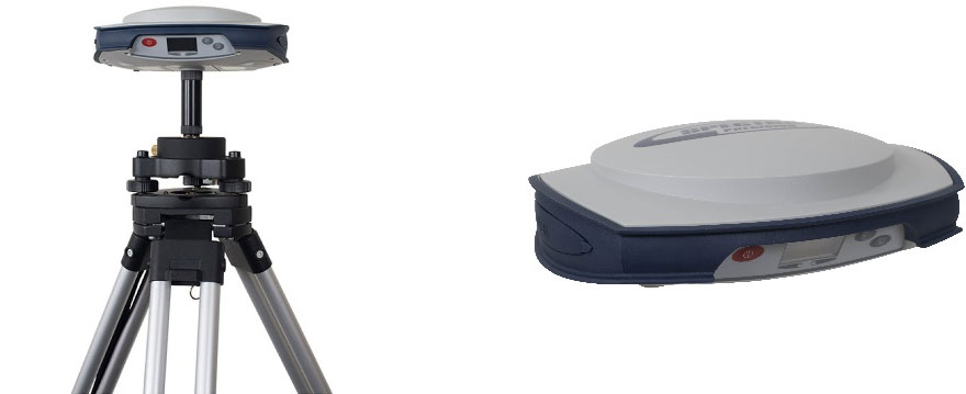
Working with Transit & Level Greensboro, SDC recently finalized the purchase of a new Spectra Precision SP80 RTK Package to support both UAS and Surveying applications. The SP80 RTK package includes:
- Two SP80 GNSS Receivers with UHF Radio and Accessory Kit
- Two Dual Chargers with Six Batteries
- Two Carlson RT3 Tablets with SurvEPC GPS
- Two Prism Pole Tripods with Data Collector Brackets
This addition to our GPS Survey resources will allow SDC to establish ground control and quality control check points for UAS LiDAR projects more efficiently, especially when operating in areas where Virtual Real Time Networks (VRN) aren’t available.
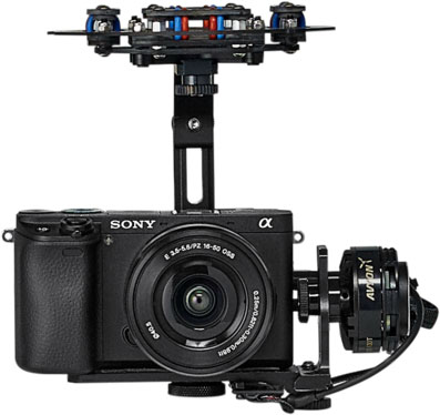
Furthering our partnership with Microdrones, SDC will be adding an upgraded payload to our mdMapper-1000 which includes a 2-axis brushless gimbal, Sony Alpha a6300 camera with variable 15-65mm lens and HD Video Link with 7” Monitor.
This upgraded payload will allow SDC to provide detailed HD video and still photography for civil, communication, utility, energy, architectural, agricultural, construction or manufacturing inspection and monitoring applications.
![]()
High Point, North Carolina (December 18, 2018)
MICRODRONES SHOWCASES END TO END WORKFLOW FEATURING SPATIAL DATA CONSULTANTS, INC.
In March of 2018, Microdrones partnered with Spatial Data Consultants (SDC), a full-service professional organization specializing in offering a wide variety of Photogrammetry, Surveying, Remote Sensing and GIS related services. Together SDC and Microdrones collaborated to bring the first mdLiDAR3000 to North America.
One of the benefits of working with Microdrones is that they have streamlined the entire process of operating their integrated systems by creating an easy end-to-end workflow: plan, fly, process and visualize. SDC and Microdrones are pleased to release 3 new videos highlighting the workflow and operations they use to help plan a mission, fly the mdLiDAR3000, and process and visualize the data.
PLAN
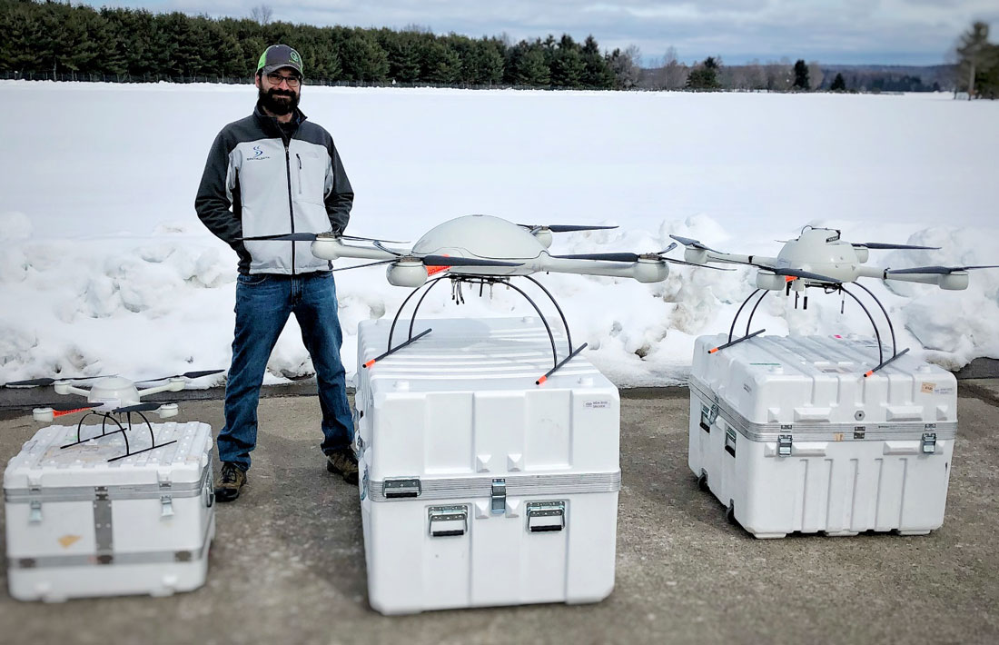
SDC is strongly committed to providing quality photogrammetry, surveying, GIS and other related services. They work on a variety of projects including landfills, transportation and other civil engineering needs. The mdLiDAR3000 helps SDC work smarter and get more done. Working with the Microdrones mdLiDAR3000 helps them deliver multiple mapping products to their customers. Check out the video above as SDC’s Robert Chrismon, Director of UAS Services and Fred Johnson, UAS Crew Chief, prep the mdLiDAR3000 and plan their flight.
FLY
Once the plan is set for the mdLiDAR3000, Robert and Fred can execute their flight and begin collecting data. Housed on board the hefty md4-3000 aerial platform, is the RIEGL miniVUX-1UAV LiDAR and a Sony RX1RII for recording color values of points. Besides viewing the mdLiDAR3000 in action, the video below also looks at some of the behind the scenes craftsmanship, design and assembly that takes place at the Microdrones facilities outside of Montreal, Canada and Siegen, Germany.
PROCESS AND VISUALIZE
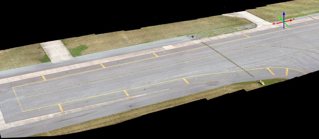
After the mdLiDAR3000 has landed and the data is collected the end result creates a point cloud visualization in standard ASPRS LAS format usable in any GIS or CAD software environment. The on- board camera also provides direct georeferenced images as well as georeferenced scan data simultaneously.
Mark Schall, Chief Professional Officer of SDC, says that their customers and employees are excited about implementing UAV integrated solutions from Microdrones. The final video highlights the visualization of the data in point cloud models and how SDC can create various mapping products for their clients.
High Point, North Carolina (August 10, 2018)
![]()
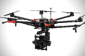
![]() SDC and Microdrones collaborate to bring the first MD4-3000 heavy lifting UAV, Riegl miniVUX-1 UAV airborne LiDAR scanner, Sony RX1-RII 42-megapixel digital camera and Applanix APX-20 UAV inertial navigation system together as a completely integrated and intelligent system for acquiring survey grade LiDAR to North Carolina.
SDC and Microdrones collaborate to bring the first MD4-3000 heavy lifting UAV, Riegl miniVUX-1 UAV airborne LiDAR scanner, Sony RX1-RII 42-megapixel digital camera and Applanix APX-20 UAV inertial navigation system together as a completely integrated and intelligent system for acquiring survey grade LiDAR to North Carolina.
After three years of research and testing various consumer off the shelf (COTS) drone and camera combinations without achieving consistent results or the accuracy necessary to meet survey mapping standards, SDC as a leader in advanced photogrammetry, can now offer our clients fast response, accurate UAS mapping using a totally integrated LiDAR and digital imagery UAS system capable of reliable and repeatable results.
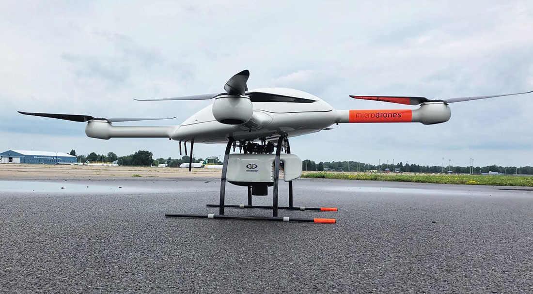 At just over thirty pounds, our MD4-3000, Riegl miniVUX-1 UAV and Sony RX1-RII acquisition system will capture survey grade LiDAR up to 100 points per square meter (ppsm) while simultaneously capturing direct geo-referenced 42-megapixel digital imagery.
LiDAR data will be post processed using MD-LiDAR and TerraSolid software platforms to provide final calibrated and classified point cloud data in LAS format to support high accuracy topographic mapping or other digital surface model (DSM) applications. Direct geo-referenced digital imagery will be post processed using Agisoft PhotoScan or Hexagon ImageStation software platforms to support digital orthoimagery production and 3D stereo feature mapping using DATEM Summit Evolution Professional and Summit UAS.
We’re extremely excited about including our MD4-3000 UAS LiDAR system in our project technical planning and workflow, we’re confident our clients will benefit from our commitment to responsible and professional UAS mapping technology development.
 For more information or technical consulting contact Robert S. Chrismon, Director of UAS Services:
rchrismon@spatialdc.com
(336) 841-1247 (office)
(336) 841-9879 (direct)
(336) 906-0426 (mobile)
![]()
High Point, North Carolina (February 5, 2018)
Robert S. Chrismon, PLS, joins SDC as Director of UAS Services.
Robert is a Professional Land Surveyor (PLS NC, L-5266), FAA Part-107 Certified SUAS Remote Pilot, Certified NC Commercial Drone Pilot, experienced Project Manager and Field Survey Crew Leader. In his role as Director of UAS and Services, Robert brings to Spatial Data Consultants, Inc., approximately 24 years of specialized expertise in the fields of Surveying, Terrestrial LiDAR, UAV LiDAR and Photogrammetry. Robert’s day-to-day responsibilities include all phases of UAS and field survey technical planning and coordination, integration of hardware and software systems, LiDAR data collection and post processing, product quality control and assurance.
 Since joining SDC in February, Robert has attended the joint International LiDAR Mapping Forum (ILMF) and ASPRS Conference in Denver, CO, the FAA UAS Symposium in Baltimore, MD and most recently conducted a demonstration flight presentation at the North Carolina Drone Summit and Flight Expo in Greensboro, NC.
Over the past seven months, Robert has been working closely with Microdrones to bring the MD4-3000 UAV, Riegl miniVUX-1 UAV airborne LiDAR scanner, Sony RX1-RII digital camera and Applanix APX-20 UAV inertial navigation system together as a completely integrated and intelligent system for acquiring survey grade LiDAR data on the most reliable heavy lifting drone platform in the industry today.
Everyone at SDC welcomes Robert and we’re all extremely excited to have him as part of the SDC Team.
Raleigh, North Carolina (September 26, 2017)
SDC Selected by NC CGIA as a Prime Vendor for the Northern Piedmont and Mountains Orthoimagery 2018 Project.
It was announced on Tuesday, September 26, 2017 that the North Carolina Office of Information Technology Services – Center for Geographic Information and Analysis (CGIA), has selected SDC as a Prime Vendor for the Northern Piedmont and Mountains Orthoimagery 2018 Project (NPM18). This is the 7th consecutive year SDC has been selected based on qualifications and past performance for the North Carolina Statewide Orthoimagery Program.
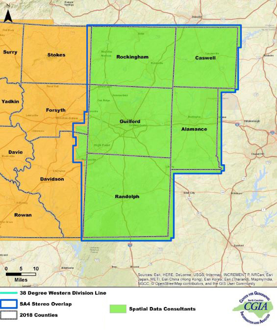
The contract is to provide Surveying, Photogrammetry and GIS services for a portion of the 26 County coastal region of North Carolina. SDC has been assigned Study Area 4 (SA4), which includes Alamance, Caswell, Guilford, Randolph and Rockingham Counties.
 Surveying, Photogrammetry and GIS services under this contract include:
- Project Technical Planning
- GPS Ground Control Survey
- Digital Aerial Imagery at 0.5’ (15cm) nominal GSD, 8-Bit RGB
- GNSS-INS and Post 5-day Post Processing
- Digital Aero-Triangulation
- Digital Photogrammetry, LiDAR DEM Update
- Digital Orthoimagery at 0’5 GSD, 8-Bit RGB, 5,000’x5,000’ Delivery Order Tiles
- Web Map Service
- Internal Level-1 Macro Quality Control and Assurance
- Level-2 through 4 Quality Control and Assurance Reporting and Resolutions
- ESRI GIS Project Management and Deliverables
- Project Technical Reporting
County or City government agencies interested in higher resolution imagery, 4-band imagery, raster impervious surface, or vector planimetric feature layers can contact Mark S. Schall, PLS, CP.
mschall@spatialdc.com
(336) 841-1247 (office)
(336) 906-3260 (cell)
 Greensboro FSDO-FAA, North Carolina (September 21, 2017)
SDC Staff Members achieve FAA Part-107 Remote Pilot Certification.
Curtis L. (Len) Tillman and Fred V. Johnson both recently passed the FAA Part-107 exam for Remote Pilot Certification. In addition, Len and Fred have each passed the NCDOT Aviation exam to obtain their NC Unmanned Aircraft Systems (UAS) Commercial Operators Permit and have each started logging UAS pilot in command (POC) hours in preparation of commercial UAS operations on behalf of SDC.
Unmanned Aircraft Systems (UAS) is also known as: Unmanned Autonomous System (UAS); Unmanned Aerial or Airborne Vehicle (UAV); or Drone.
Commercial UAS Operations Include:
- Television or Video Production (Video)
- Adverting (Imagery or Video)
- Inspections (Imagery or Video)
- Photogrammetric Mapping Applications
- Imagery Acquisition
- Aero-Triangulation
- Elevation Point Cloud Generation
- Digital Orthoimagery
- LiDAR Acquisition
 Raleigh, North Carolina (September 19, 2017)
SDC Awarded NCDOT Limited Services Agreement (LSA) for Aerial Acquisition Services.
It was announced on Tuesday, September 19, 2017, that the North Carolina Department of Transportation, Professional Services Management Unit, has awarded a three-year LSA to SDC.
The LSA is to provide aerial acquisition services, statewide, during 2018, 2019 and 2020, to support the efforts of the North Carolina Department of Transportation Photogrammetry Unit.
Aerial acquisition services under this contract include:
- Digital Aerial Imagery
- Airborne Topographic LiDAR
- Airborne Bathymetric LiDAR
- GNSS-INS
- Unmanned Aircraft Systems (UAS)
- Project Technical Reporting
Raleigh, North Carolina (September 19, 2017)
SDC Awarded NCDOT Limited Services Agreement (LSA) for Photogrammetry Services.
It was announced on Tuesday, September 19, 2017, that the North Carolina Department of Transportation, Professional Services Management Unit, has awarded a three-year LSA to SDC.
The LSA is to provide photogrammetric mapping services, statewide, during 2018, 2019 and 2020, to support the efforts of the North Carolina Department of Transportation Photogrammetry Unit.
Photogrammetry services under this contract include:
- Digital Aero-Triangulation
- Digital Planimetric Mapping
- Digital Terrain Model Mapping (DTM)
- Digital Orthoimagery
- Field Survey Classification
- Project Technical Reporting
Raleigh, North Carolina (March 20, 2017)
NCDOT assigns SDC the quarterly B-2500, NC12 Replacement of Herbert Bonner Bridge and Coastal Monitoring Effort Project in Dare County
The Herbert C. Bonner Bridge, which carries NC12 over Oregon Inlet between Hatteras and Bodie islands, is well past its design life and is being replaced with a new bridge that will better withstand its coastal environment.
The B-2500 Project study area encompasses approximately 8,400 acres of Bodie and Pea Islands along the Outer Banks of NC. On a quarterly basis, SDC will provide detailed planimetric and digital terrain model mapping to monitor environmental conditions, most specifically the impact of weather trends, storm surge, tidal fluctuation and surf erosion on the beach and sand dunes.
 Photogrammetry services for B-2500 include:
- Digital Aero-Triangulation
- Digital Planimetric Mapping
- Digital Terrain Model Mapping (DTM)
- Digital Orthoimagery
- Project Technical Reporting
Raleigh, North Carolina (October 18, 2016)
SDC Selected by NC CGIA as a Prime Vendor for the Eastern Piedmont Orthoimagery 2017 Project
It was announced on Tuesday, October 18, 2016 that the North Carolina Office of Information Technology Services – Center for Geographic Information and Analysis (CGIA), has selected SDC as a Prime Vendor for the Eastern Piedmont Orthoimagery 2017 Project. This is the 6th straight year SDC has been selected based on qualifications and past performance for the North Carolina Statewide Orthoimagery Program.
The contract is to provide Surveying, Photogrammetry and GIS services for a portion of the 26 County coastal region of North Carolina. SDC has been assigned Study Area 1 (SA1), which includes Wake, Granville, Lee, Chatham, Durham, Orange and Person Counties.
 Surveying, Photogrammetry and GIS services under this contract include:
- Project Technical Planning
- GPS Ground Control Survey
- Digital Aerial Imagery at 0.5’ (15cm) nominal GSD, 8-Bit RGB
- GNSS-INS and Post 5-day Post Processing
- Digital Aero-Triangulation
- Digital Photogrammetry, LiDAR DEM Update
- Digital Orthoimagery at 0’5 GSD, 8-Bit RGB, 5,000’x5,000’ Delivery Order Tiles
- Web Map Service
- Internal Level-1 Macro Quality Control and Assurance
- Level-2 through 4 Quality Control and Assurance Reporting and Resolutions
- ESRI GIS Project Management and Deliverables
- Project Technical Reporting
County or City government agencies interested in higher resolution imagery, 4-band imagery, raster impervious surface, or vector planimetric feature layers can contact Mark S. Schall, PLS, CP.
mschall@spatialdc.com
(336) 841-1247 (office)
(336) 906-3260 (cell)
Raleigh, North Carolina (October 20, 2015)
SDC Selected by NC CGIA as a Prime Vendor for the Coastal Orthoimagery 2016 Project
It was announced on Tuesday, October 20, 2015 that the North Carolina Office of Information Technology Services – Center for Geographic Information and Analysis (CGIA), has selected SDC as a Prime Vendor for the Coastal Orthoimagery 2016 Project. This is the 5th straight year SDC has been selected based on qualifications and past performance for the North Carolina Statewide Orthoimagery Program.
The contract is to provide Surveying, Photogrammetry and GIS services for a portion of the 27 County coastal region of North Carolina.
Surveying, Photogrammetry and GIS services under this contract include:
- Project Technical Planning
- GPS Ground Control Survey
- Digital Aerial Imagery at 0.5’ (15cm) nominal GSD, 8-Bit RGB
- GNSS-INS and Post 5-day Post Processing
- Digital Aero-Triangulation
- Digital Photogrammetry, LiDAR DEM Update
- Digital Orthoimagery at 0’5 GSD, 8-Bit RGB, 5,000’x5,000’ Delivery Order Tiles
- Internal Level-1 Macro Quality Control and Assurance
- Level-2 through 4 Quality Control and Assurance Reporting and Resolutions
- ESRI GIS Project Management and Deliverables
- Project Technical Reporting
Raleigh, North Carolina (September 11, 2015)
SDC Awarded NCDOT Contract for Photogrammetry Services
It was announced on Friday, September 11, 2015 that the North Carolina Department of Transportation, Professional Services Management Unit, has awarded a two-year contract to SDC.
The contract is to provide photogrammetric mapping services, statewide, during 2016 and 2017, to support the efforts of the North Carolina Department of Transportation Photogrammetry Unit.
Photogrammetry services under this contract include:
- Digital Aero-Triangulation
- Digital Planimetric Mapping
- Digital Terrain Model Mapping (DTM)
- Digital Orthoimagery
- Field Survey Classification
- Project Technical Reporting
Raleigh, North Carolina (September 11, 2015)
SDC Awarded NCDOT Contract for Aerial Acquisition Services
It was announced on Friday, September 11, 2015 that the North Carolina Department of Transportation, Professional Services Management Unit, has awarded a two-year contract to SDC.
The contract is to provide aerial acquisition services, statewide, during 2016 and 2017, to support the efforts of the North Carolina Department of Transportation Photogrammetry Unit.
Aerial acquisition services under this contract include:
- Digital Aerial Imagery
- Airborne Topographic LiDAR
- Airborne Bathymetric LiDAR
- GNSS-INS
- Unmanned Aircraft Systems (UAS)
- Project Technical Reporting
Magazine Articles
 Professional Surveyor (Spring 2013)
http://www.xyht.com/professional-surveyor-archives/ensuring-quality/
Ensuring Quality
“North Carolina raises the bar for Orthoimagery accuracy in a Statewide Project”
Mark S. Schall, CP, PLS, PPS, SP, Chief Professional Officer at SDC, was a major contributor for this article which chronicles the quality control and assurance development cycle for the North Carolina Statewide Orthoimagery Program implemented by the State Project Team to ensure horizontal accuracy and radiometric consistency in compliance with the State Standards.
The North Carolina State Project Team is made up of the following agencies:
- 911 Board
- Secretary of State’s Office
- Center for Geographic Information and Analysis
- Department of Transportation Photogrammetry Unit
- Geodetic Survey